
We are already experiencing extreme weather on our planet. How are these events increasing with higher temperatures?
More than 200 million people globally are already experiencing extremely hot days with temperatures above 35°C (95°F).
Scientists tell us that this is just the beginning.
If Earth’s average temperature rises by 1.5°C (2.7°F), models predict that some parts of our world will see a rise of 3°C (5.4°F) or higher.
Heatwaves will become more frequent and intense. Moisture in the soil will evaporate, and plants will dry out.
These hot and dry conditions make plants flammable and prone to wildfires. Long periods of heat and less rain can worsen droughts and extend the fire season. This means more wildfires are likely to start.
Precipitation and Intense Storms

As the atmosphere warms, it can hold more water vapor.
Did you know that for every 1°C increase in temperature, the atmosphere can hold around 7% more water vapor?
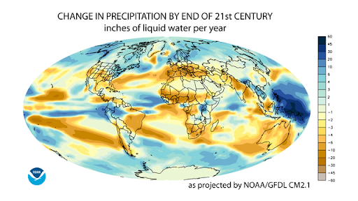
When more water evaporates from oceans, rivers, and lakes, it will cause heavier rainfall. This can lead to flooding events such as rivers overflowing their banks or water gushing through city streets.
However, this precipitation will not be uniform across our planet. Some places will get wetter, like South Asia. Other places, like South Africa, will experience droughts.
Figure 4.2.3 shows what the world might look like as precipitation patterns change. What do you notice?
The higher water vapor in the atmosphere will make tropical storms and hurricanes more intense. It will also make them more frequent and last longer, with storm surges.
Why Jet Streams Matter

Research shows that rising temperatures and the warming Arctic are changing atmospheric winds called jet streams.
Generally, jet streams are stable and flow from the west to the east due to the rotation of the Earth. They are driven by the temperature difference between the cold Arctic air at the poles and warmer air further south.
However, with rising temperatures in the Arctic, these streams are becoming increasingly weak and wobbly.
A wavy jet stream pushes cold air further south during winters and into cities in North America and Europe. This brings cold snaps and blizzard conditions (see Figure 4.2.4).
Now that we’ve seen how rising temperatures lead to more extreme weather conditions, let’s take a look at the impact on global water systems next.
Summary
- Climate models predict that rising temperatures will lead to more heatwaves, droughts, and wildfires.
- Higher ocean temperatures will cause more heavy rainfall events and flooding.
- Higher temperatures in polar regions will bring frigid winters to cities in North America and Europe.
Today, over 200 million people globally experience extremely hot days with temperatures above 35°C (95°F). Scientists warn that this is only the beginning.
If Earth’s average temperature rises by 1.5°C (2.7°F), some regions could warm by 3°C (5.4°F) or more. This means more frequent and intense heatwaves, which are defined as periods of unusually hot weather lasting at least two days.
Rising temperatures dry out soils and plants, making them highly flammable and prone to wildfires. Long periods of heat and less rain can worsen droughts and lead to longer and more dangerous fire seasons.
Precipitation and Intense Storms
Warm air can hold more water vapor. In fact, for every 1°C increase in temperature, the atmosphere can hold about 7% more water vapor.
This means that as the planet warms, more water evaporates from oceans, rivers, and lakes, leading to heavier rainfall. This can cause flash floods, river floods, and even urban floods when drainage systems in cities can’t keep up.
But these changes won’t be the same everywhere. South Asia is expected to get wetter, while the Mediterranean and South Africa may get drier. These uneven patterns will reshape ecosystems and communities worldwide.
Figure 4.2.3 shows what the world might look like as precipitation patterns change. What do you notice?
At the same time, higher water vapor content in the atmosphere would increase the intensity of hurricanes and tropical storms. This would result in heavier rainfall and higher storm surges as strong winds push ocean water inland and flood coastal areas.
Why Jet Streams Matter
Research shows that rising temperatures and the warming Arctic are altering atmospheric winds called jet streams that influence weather patterns.
Generally, jet streams are stable and flow from the west to the east due to the rotation of the Earth. They are driven by the temperature difference between the cold Arctic air at the poles and warmer air further south.
But as the Arctic warms faster than the rest of the planet, jet streams become increasingly weak and wobbly. A wavy jet stream pushes cold air further south during winters and into cities in North America and Europe, bringing cold snaps and blizzard conditions (see Fig. 4.2.4).
Now that we’ve seen how rising temperatures lead to different extreme weather conditions, let’s look at the impact on global water systems next.